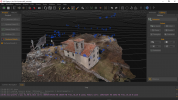
Welcome DJI Spark Pilot!
Jump in and join our free Spark community today!
Sign up

Ortophoto as the result of spark fotogrametry

For ortophoto I use:
- DJI Flight Planner to prepare the mission
- Litchi to control the mission on the ground
- DJI Spark to flight the mission and take the photo
- 3D Zephir to reconstruct the 3D model from photo
Attached an exemple. The only thing I lack is a GPS station to set precise ground control point.

Nice to share experiences.
GLB
 

Attachments

  • 3DZephir.PNG
    3DZephir.PNG
    762.4 KB · Views: 11
  • Like
Reactions: RotorWash
For ortophoto I use:
- DJI Flight Planner to prepare the mission
- Litchi to control the mission on the ground
- DJI Spark to flight the mission and take the photo
- 3D Zephir to reconstruct the 3D model from photo
Attached an exemple. The only thing I lack is a GPS station to set precise ground control point.

Nice to share experiences.
GLB
Thanks for the sharing information.. Yes I agree with you..we must make at least 4 control points using geodetic GPS to set precise position...
Sincerely yours..
 
  • Like
Reactions: RotorWash

New Posts

Members online

No members online now.

Forum statistics

Threads
14,600
Messages
118,822
Members
18,008
Latest member
jobaeit