Welcome DJI Spark Pilot!
Jump in and join our free Spark community today!
Sign up

Spark flew away (with flight records)

Sparky80

New Member
Join
May 17, 2021
Messages
4
Age
44
Hi Experts,

My spark suddenly took off. Seems some GPS error and took off with the wind. It is not at the last known GPS location (still 108 ft.)

Flight logs are uploaded here: DJI Flight Log Viewer - PhantomHelp.com
or attached.

Can someone estimate where it might have landed?

Thank you
 

Attachments

  • DJIFlightRecord_2021-05-16_[15-08-16].txt
    304.6 KB · Views: 16
Not 100% sure there are any flight log analysts here Sparky80.
I haven't seen a detailed report and search location on this particular forum.

Best bet if no one comes up with anything here, pop over to MavicPilots forum, you'll have to register, and go to the Mavic Crash & Flyaway section.
Ask very nicely, if someone there can take a look at your flight, and if they can give you a search area.

They are REALLY good there, have a read through some of the cases, more than a few have found their drones with the help given.
And I'm sure that even though it's not a Mavic, someone (perhaps more than one) will have a good look for you.

I'm no expert, but it seems like a strange log.
Yaw error in particular, atti mode even though 21 sats.

At the end when signal lost, you had 64% battery, at 108 feet, and no movement . . . was there no wind, it seemed to be almost stationary moving so slowly all that time in atti mode ?
If that is correct it probably just hovered there until the battery gave out, may have auto landed, it could have RTH, did you stay at home point a while after ? Possibly the compass / yaw errors didn't allow this to happen.
You didn't touch the sticks the whole time it was in atti mode ?
Thanks, will check in the other forum.

For sure there was wind, indeed strange last two entries are 0 speed, while all others before are indicating it is dragged by wind.

I did not touch controls because I did not visually see the drone anymore and trying return to run towards it and pressing RTH. I only noticed later it was in Atti mode. too late.
It indeed never returned to home. we checked later for sure.

I did notice the attitude pitch on the bowl meter, when in control in P mode, both left and right pitching, so there was a good wind coming from the south ?
The drone must have been trying to control it's location and was only going 0 - 2 or so km/hr most of the blow away part of the flight in atti,
Didn't notice the pitch on attitude bowl meter was unusual though, sort of confusing.

In hindsight, if you had the green RTH line on the drone to show the way home early (you only had 1 minute to do this from the time it went atti), you could have the Spark direction towards you, right stick down drop from 320' to 100' where the wind was possibly lower, and same time full right stick forward towards home.
Not sure it would have made it in atti mode, sports mode possibly.

The height of the flight for wind was simply too much for the drone this time.
The reason for atti mode will be interesting if it can be worked out.

Well, I hope to see your post in that MavicPilots section soon, and you get some good replies.
I am amazed by the predictions sometimes and locations / success given.

My guess is you might be lucky in that with 64% battery left, and the direction it was being blown, would have likely ended up in towards that farming lands, possibly as far as the suburb of Munnikhove, it sould have had enough battery and height as the wind still took it to get blown over the far side to and past Modderbeek, and more farm lands.
Farm lands are better than suburbs usually, especially if open.
Town they often end up lost in a garden, on a roof, people find and take away, etc etc, at least paddocks they can be clear and allow some chance.

The further the possible landing zone, the more allowance for drift has to be taken into account, hopefully your search area can be narrowed down well.

Best of luck.
 
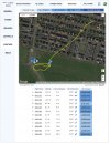
Thought I'd throw this wind map in here for you from Airdata. The wind info is not precise and the lack of gps only allowed a few early data points but it may help a bit. Although you had 6+ minutes of battery remaining, I've read that when the Spark is in ATTI and loses RC connection for a few seconds that it will try to autoland at its current location. Due to lack of positioning however, it will drift with the wind on its descent. Good luck!

windprofile .jpg
 
  • Like
Reactions: Spark 317
Thanks all. We tried to search the area after disconnect and in Atti mode at last known GPS data, but no luck. At the time we tried to connect the remote in that area but no luck only 10min later.

If it initiated auto landing few seconds after disconnect, unsure why the remote would not connect again as we were close by that area. Unless wind dragged it much further when decending for auto landing.

There are some houses that area during disconnect, so easy could have landed in a garden, then it is considered gone I guess...
 
Does it give data on wind at 108 feet when it was being blown away ?
That was from 3 mins 5 secs.

It was likely more up higher because Spark was unable to hold its position, drifting between 1/2 and 2.5 m/hr NE.
The Airdata wind calculations require a functioning GPS and the last wind data point @ 02m.35s was just before the craft started having issues so nothing after that. The altitude at that point was 34.3m and the last altitude measurement in ATTI, just before losing signal, was at 33m (04m.03s).
 
There are some houses that area during disconnect, so easy could have landed in a garden, then it is considered gone I guess...
I've heard of others having success by posting a notification in the area, might be worth a shot. If autoland kicked in as it should (~3secs) then it shouldn't be much more than 250' from the last point of reference depending if it came into contact with anything on its decent.
 
I'll throw in my fuzzy math.

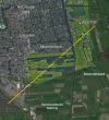
With 64% battery at 108 feet up in Atti-mode, if the wind was blowing to the NE, the Spark may have drifted up to two miles away drifting 19 feet per second with the reaming battery time of approximately 9.75 minutes left.

The Spark should maintain the altitude but drift with the wind until the battery gets low enough to self land.

It could have reestablished a GPS lock somewhere along the way and tried to make it back home but couldn't make it and self landed.

Or it drifted at 108 feet until it hit something 109 feet tall along the way.

Screenshot_20210519-205620.png


Use this weather page for the date and time of your flight for the wind speed and direction at the time to help with a search area.


Good luck and happy hunting. :)
 
  • Like
Reactions: RotorWash
I'll throw in my fuzzy math.

With 64% battery at 108 feet up in Atti-mode, if the wind was blowing to the NE, the Spark may have drifted up to two miles away drifting 19 feet per second with the reaming battery time of approximately 9.75 minutes left.

The Spark should maintain the altitude but drift with the wind until the battery gets low enough to self land.

It could have reestablished a GPS lock somewhere along the way and tried to make it back home but couldn't make it and self landed.

Or it drifted at 108 feet until it hit something 109 feet tall along the way.

View attachment 13791


Use this weather page for the date and time of your flight for the wind speed and direction at the time to help with a search area.


Good luck and happy hunting. :)
Thank you. Quite some terrain and not all accessible unfortunately.

What is still unclear is if the Spark would start to autoland after few sec when in ATTI and lost connection with the RC.
 
Thank you. Quite some terrain and not all accessible unfortunately.

What is still unclear is if the Spark would start to autoland after few sec when in ATTI and lost connection with the RC.

With no stick input, and obviously moving very slowly with the wind (which must have been blowing enough so it couldn't maintain position), it SHOULD have kept drifting until low battery forced landing.
Thinking about that, being in atti too it would have just drifted like that with the wind, if it somehow got signal back it would likely have been far enough away to start a RTH low battery failsafe, and that may have partially happened . . . could be a tough one to work through, best to assume it just stayed in atti.

Of course if it remained in atti, it could have drifted any direction slightly, more at any shifts of the wind and possibly some vertical movement.

Best thig to do is post to Mavic section as advised, ask politely if anyone can give you a quick idea of best likely spot to search.
Read some of the posts there, they are very good at this.
Time is ticking, don't want it out there any longer than necessary.
 
What is still unclear is if the Spark would start to autoland after few sec when in ATTI and lost connection with the RC.
Here are some references about the ATTI/lostlink/autoland scenario; 1, 2, 3, 4. Appears to apply so long as you didn't have your failsafe action set to hoover. Also, where the log file ends, we know you have lost the downlink but we can't be sure you also lost the uplink from the RC at the same time. If it managed to hold on for awhile, even intermittently, it's going to add some time before decent begins.
 
Last edited:
Certainly wouldn't hurt to ask, sar104 & BudWalker are two of my fav drone whisperers over there.

Indeed, and Slup is really good now too . . . all 3 seem to feed / learn things from each other.
The software they have (and share) is really good at bringing out all the info needed to get the estimates for position, as well as the real causes of a crash / loss.
While most are pilot error, I've seen more than a few with equipment failure where the OPs have gone on to get a replacement . . . sometimes DJI don't dig as deep as these analysts do.
 
HI, guys chiming in here as I experienced my 1st flyaway last week with a Spark. I certainly am not immune to pilot error as we can all make mistakes. On that note, I'd like to learn from my mishap so I can avoid this again if possible. Here's my story...I was flying a 3D mapping mission using a 3rd party iOS App called 3D Survey Pilot which I had successfully used on at least 10 occasions without issue. I was flying a construction site with a preplanned flight that had been used multiple times over the span of a few months never with an issue. The day I flew it was clear, sunny, and calm. Before taking off I ensured I had a GPS lock with at least 11 satellites to my memory. The home point had been recorded and I had the settings enabled to return to home on low battery or when the drone hit a threshold distance from the home point. All was normal...battery at 96% etc. The drone launched and did its autonomous mission and was beeping to return to home as normal. I watched as the drone returned to the home point XY where I was standing. The Spark briefly paused to begin descending, however instead of descending it just beelined at speed away from my mission area and would not respond to the RC controller pause and RTH commands or iOS pause and RTH commands! On the screen, an error popped up that said "Abnormal compass function or GPS signal detected. The aircraft is switched to ATTI mode". I was able to see the camera feed for about another 5 minutes until the feed dropped despite the drone not responding to commands from the RC or the 3D Survey Pilot app or the DJI GO App. Further frustrating is that due to the error the map dropped so I could not see the location of the Spark other than the camera feed. At that point, VLOS was gone...This is a huge mystery to me as to what happened and concerns me for future flights. I've purchased a Mavic Pro but feel apprehensive to perform autonomous flights after this mishap. Does anyone else on this thread have ideas or have experienced a similar flyaway? I never found the Spark...Rest in peace old bird :(
 
HI, guys chiming in here as I experienced my 1st flyaway last week with a Spark. I certainly am not immune to pilot error as we can all make mistakes.


Hello from the Hoosier Heartland gisdowntime.

Sorry to hear about your Spark.

I'm not an expert at reading the flight logs in detail, but if you follow the instructions from this site and post a link back to here, it may be a start to unraveling the mystery. 🤔


Good luck and welcome to the Forum. :cool:

.
 
  • Like
Reactions: Dragonfly Joe
Welcome to the forum.

Being a 3rd party app, you might find the flight record compatible, and in the usual folder . . . or, you might have to dig to find a flight record, and then it may or may not be compatible.
Both Spark and M1P are really good mapping drones usually, used with many compatible apps.
Hopefully you don't have too many problems getting into that with the M1P.

If you really get stuck, upload the log to mavicpilots.com for the analysts there to take a look.
I'm sure most won't mind helping with the different model, still DJI . . . and especially as you register / introduce yourself there with your new Mavic on that forum anyway, and ask if anyone can help you work out what happened to the Spark.
Post an intro in the new pilot section, then the Crash section for some help, hopefully the flight record can be deciphered.
 
Hello from the Hoosier Heartland gisdowntime.

Sorry to hear about your Spark.

I'm not an expert at reading the flight logs in detail, but if you follow the instructions from this site and post a link back to here, it may be a start to unraveling the mystery. 🤔


Good luck and welcome to the Forum. :cool:

.
Hey thanks for this advice on the flight log! I wish I had known about this tool on the day it happened. If I get extremely lucky It will still be there tomorrow! Oddly the map has my starting point wrong. It's missing the entire beginning of my flight where I did the mapping mission. DJI Flight Log Viewer - PhantomHelp.com
 
  • Like
Reactions: Spark 317
As it was auto landing you should be lucky there, it should have landed somewhere right there.
Great (lucky) you flew a decent mission and battery was low / drone was close and still had drone - controller signal.
Hopefully it's still there, I guess if a game was on / has been held since, if it was found you had your contact info marked on the drone and someone might call to return it.
(Did you really take off with 44% battery though ?)

It looks like a classic yaw error caused by imu / compass disagreement at start up, perhaps autonomous flight was all fine by GPS, then when it went into normal rth / landing ops, the disagreement casued it to fly away.
Local magnetic interference causes this at take off, and if not noticed to correct things, leads to the aircraft taking off very often at 90 degrees or so.
Best practice is ensure when the lady says "home point recorded, please check it in the map" you look at the map and ensure the red arrow drone direction is relatively right for the way the drone faces on the ground.

Good luck with finding it, please update.
 
  • Like
Reactions: Spark 317

Members online

No members online now.

Forum statistics

Threads
14,601
Messages
118,823
Members
18,012
Latest member
Dayanadiast