Welcome DJI Spark Pilot!
Jump in and join our free Spark community today!
Sign up

Spark for 3d Land Mapping

coconuts

Member
Join
Sep 4, 2017
Messages
7
Age
45
Hi all,

I was just wondering if anyone has used any of the popular 3D mapping solutions like Pix4D or DroneDeploy to map an area with the Spark?
The Spark does not support waypoint flying so I guess you'd have to fly it manually.
I could do with some sort of end to end tutorial if anyone knows of one.

Many thanks!
 
1080p is a little on the lower side for imagery quality. Flight time is limited. But after market products like Autopilot or Kittyhawk have waypoint flying for Spark.

Why not try?
 
I have tried pix4d but my spark wasn't really working so i gave up after 5 min

bennie
 
I think it was the spark itself having problems flying will try again when im home now its working properly

bennie
 
1080p is a little on the lower side for imagery quality. Flight time is limited. But after market products like Autopilot or Kittyhawk have waypoint flying for Spark.

Why not try?
It is the picture quality that count, not the video. It should not be that bad for such kind of application.
The main limitation will be the autonomy.
 
  • Like
Reactions: djmatt
It is the picture quality that count, not the video. It should not be that bad for such kind of application.
The main limitation will be the autonomy.
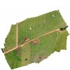
Ortho_3_White.jpg

Agreed. I've made a very high resolution composite image from about 100 images with the drone at 80m above ground level, but flying the drone in perfect flight lines isn't easy. So I would really appreciate it if DJI will add waypoint mode for the Spark.
 
In theory there is the Pix4d app that should work with the Spark to capture an area on a map. I used it with Phantom 3.
I made a short try this evening, but I need to invest more time in learning how it works now.

Sent from my SM-G950F using SparkPilots Spark Forum mobile app
 
Agreed. I've made a very high resolution composite image from about 100 images with the drone at 80m above ground level, but flying the drone in perfect flight lines isn't easy. So I would really appreciate it if DJI will add waypoint mode for the Spark.
Looks very nice.

I was not able to fly using their app to do the capture using a flight plan.(Ctrl+DJI or Pix4Dcapture), need probably to read some more docs.
I just fly (circling) around the object (buried water tank) manually and took 62 pictures pointing to the object (1 battery, so fast). It was not high light so I add to tune to get a speed of at least 1/100 to take picture while flying. The first circle was at 1/30 but I had to stop to take each picture, I had to delete several, out of focus.
Finally, after long processing something comes out of Pix4Dmapper (Pix4Ddesktop 3.3.29) on the screen.
It is not that bad considering the few pictures I took. But it is almost the point of view from the Spark. If you zoom more, then the details becomes more ugly. Would need more pass closer to some of the concrete boxes and probably also a pass from the top in the horizontal plane above the object.
Capture12.PNG
Capture13.PNG
"Processed with Pix4Ddiscovery by Pix4D", no output enabled.

The point is now that it is the free version and apart screen-copies, there is no output enabled, so the use is limited as a free version, which is ok as you can rent it on monthly basis.
 
  • Like
Reactions: keune
Can someone please explain what I am doing wrong? I've been UAV survey pilot for a couple years now and purchased a Spark mostly for tight spots and building interiors, but flew it with Litchi today as a mapper and the coordinates are rounded to the nearest second? Is there something I need to do to get more accurate EXIF data?
 
There is a discussion on the DJI Spark forum at the moment about this. It appears that coordinates are only stored to 4 dec places.
 
Thanks @mik , I have been keeping an eye on it, but am curious how some people have been able to make ANY maps? I can easily capture the map autonomously with Litchi, but the best I've been able to do is create a 2D orthomosaic with Microsoft ICE. Neither Pix4d nor DroneDeploy are able to stitch these together because of the coordinates. I guess I'll believe it when I hear an actual workflow and/or see a processing or accuracy report.
 
I was able to make a coloured contour map and 3D model flying Spark by eye and importing images to DroneDeploy but my month free trial ran out some time ago and they have just informed me that they have deleted my account because lack of use so I can't show it to you. I am not sure if DJI have changed recorded coordinate accuracy since then. Have you got lots of overlap (left right fore back) on your photos?
 
I flew less than an acre and 140 images showed up in 4 or 5 spots when uploaded so they were obviously using the rounded coordinate. It must be something that changed recently. My Spark says it is updated.
 
I have not updated my firmware. I get the foloowing EXIF data. How does it compare to yours?


43 deg 13' 12.00" N,
0 deg 52' 47.00" E
 
Those are similar. Note the seconds St XX.00". because they are rounded to the nearest Second you could be as much as 0.49 seconds off which to a lot of people doesn't sound like a lot because of the way they think about seconds but when you think of a degree of latitude or longitude I could be as much as 40 feet. To even have a chance of any kind of usable accuracy it would need to be to the thousandth of a second. Which means that all three decimal places would have a value.
all that being said I got a response back from DJI and they don't plan on fixing it anytime soon. I guess I won't be mapping with the Spark. It's too bad because it could have been entirely capable of doing so.
 
Ground control points
Can someone please explain what I am doing wrong? I've been UAV survey pilot for a couple years now and purchased a Spark mostly for tight spots and building interiors, but flew it with Litchi today as a mapper and the coordinates are rounded to the nearest second? Is there something I need to do to get more accurate EXIF data?
 

Members online

Forum statistics

Threads
14,593
Messages
118,799
Members
17,987
Latest member
csdisme