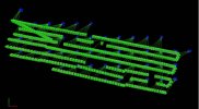
Hi, I've noticed that when doing a photogrammetry mission with Spark, the photo coordinates in the EXIF geotag will be spaced by exactly 30 meters (in the N//S/E/W directions), that is if I take a photo every 5 meters in a direction E/W or N/S, the consecutive 6 photos will have the exact same geotag position.
Is this a bug or a specific parameter in Spark firmware that I have to change ?
That's really weird since I've never seen any occurence of that in the forums.
See attached a pix4d map view : In blue : the geotag positions, in green, the real positions (recalculated by pix4d).
Is this a bug or a specific parameter in Spark firmware that I have to change ?
That's really weird since I've never seen any occurence of that in the forums.
See attached a pix4d map view : In blue : the geotag positions, in green, the real positions (recalculated by pix4d).