Welcome DJI Spark Pilot!
Jump in and join our free Spark community today!
Sign up

Lost Spark

grounded

Member
Join
Aug 28, 2020
Messages
17
Age
76
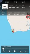
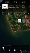
I can view the flight records and see where he went down on the map, but the map only shows the streets and I can't seem to figure out how to get a satellite map to be able to see the structures in the area. I tried downloading a map, but I still only see the streets. What am I doing wrong?
Many Thanks.....
p.s. Using an android phone
Does this help any or are you viewing the map from a different source? If a satellite view hasn't been loaded for that area previously, you'll need an active Internet connection to download the overlay to the phone.

ss-map1.jpgss-map2.jpg
 

Members online

No members online now.

Forum statistics

Threads
14,601
Messages
118,823
Members
18,013
Latest member
ChunGreenh