
Lost my spark today while on vacation in North Carolina. I was flying close to a no fly zone which also happened to be a park area with a salt water marshy area. The drone all if the sudden said landing while I was over the water marshy area. I couldn’t stop it from landing. I’m pretty new at this drone stuff. The drone landed and I list connection. My remote was still beeping and I tried to search for it the marshy area in a Conoe but to no avail I couldn’t find it. Would the drone land itself in the water maybe mistaking the marshy area for ground. Not sure what happened. Any ideas?

You are using an out of date browser. It may not display this or other websites correctly.
You should upgrade or use an alternative browser.
You should upgrade or use an alternative browser.
Lost my spark today
- Thread starter Jeffro
- Start date
Tentoes
Well-Known Member
Ow...
Can you take the canoe out again? Bring your phone. Go4 knows where it last saw your drone. Tap in the upper right and select "Find my drone." It will draw you a map with a line between your current location and the point it last had contact with the drone.
Hope it is not actually in the water.
If it IS in the water, hope it is not salt water.
If it is not salt water, take off the battery and stick the drone in a bag of rice for a couple days and it might live.
If it is salt water, you're screwed.
SoccerRef12
Well-Known Member
Upload your flight log to DJI Flight Log Viewer | Phantom Help then post a link to it back into this thread and a lot of smart folks here can tell you what happened. Good luck!

Here is a video and flight path log I have. See what you think. Thanks I’ll give with the find my drone thingy.Ow...
Can you take the canoe out again? Bring your phone. Go4 knows where it last saw your drone. Tap in the upper right and select "Find my drone." It will draw you a map with a line between your current location and the point it last had contact with the drone.
Hope it is not actually in the water.
If it IS in the water, hope it is not salt water.
If it is not salt water, take off the battery and stick the drone in a bag of rice for a couple days and it might live.
If it is salt water, you're screwed.
Attachments
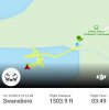
Here is the video. Looks like in the water.Here is a video and flight path log I have. See what you think. Thanks I’ll give with the find my drone thingy.
Hey thanks. I’ve got the last video and flight log and I’m thinking its in the water had some people in kayaks that paddled out to take a look around but couldn’t find. I should have been more wary of the drone warning me of restricted air space. Camp lejeune is pretty close and I guess this is what caused the drone to land. And I guess it couldn’t navigate the ground due to the marshy ground water. The video looks like a splash as the video stops. Probably salt water mix in this cedar point area. Going to check in the morning and some kayakers are going to take my controller with the app opened and hit the button —find my drone. A lot of North Carolinians helping out to find it. Great people.Wish I were closer, I'm about 2 hours inland from there. With any luck it landed on a grassy portion of the marsh, keep us posted.
Camp lejeune is pretty close and I guess this is what caused the drone to land.
I have read other posts concerning the NFZ's and like your experience, the Spark decides to land with no input from the controller.
I think it sucks that you can't control the aircraft to a safe location.
I watched a Phantom flight video a couple of years ago. It stopped and hovered when it hit a NFZ.
The pilot was able to fly it backwards away from the area and land safely.
STEPASYD
Well-Known Member
- Join
- Dec 20, 2019
- Messages
- 48
- Age
- 39
Did a little more searching from the B4UFLY app, looks like that is restricted airspace. I'm so new to flying that this is new to me. I like out in the middle of nowhere and I've only had my spark a few weeks, so I've yet to encounter anything of this nature, but surely somebody can chime in...
Right you are! I tried everything. I was 500 ft high and couldn’t stop itI have read other posts concerning the NFZ's and like your experience, the Spark decides to land with no input from the controller.
I think it sucks that you can't control the aircraft to a safe location.
I watched a Phantom flight video a couple of years ago. It stopped and hovered when it hit a NFZ.
The pilot was able to fly it backwards away from the area and land safely.
There is a video out there of a guy blaming DJI for his woes although he stated he forgot about a pending Temp Flight Restriction (TFR) that went into effect while he was flying in the zone. He had forward motion trying to return but "UP" control would not work. Finally landed in the water about 1000ft out.
Sorry to hear.
Used to be my old stomping grounds - former Marine.
Don't let this stop you from the hobby.
And use the app AirMap before flying.
Even though B4UFly was created by the FAA and recently backed by KittyHawk company, AirMap has their stuff together.
Just make sure to zoom in on the area you will be flying in.
The app shows you all the warnings visible on the screen.
Meaning when you open the app, you may see a NFZ.
But on closer inspection, that NFZ may be 10 miles away from where you will actually be flying.
Had that happen to me today , I wasn’t in any nfz. I flew once then changed battery on the second flight my spark took off fine flew a few hundred metres had the red lights on to indicate it was recording then suddenly stopped and decided to land itself. Luckily wasn’t far away but the interesting thing is there is no log of the flight and no video recorded I’m at a loss as to what happened
hiflyer
Well-Known Member
- Join
- Sep 12, 2018
- Messages
- 349
- Age
- 87
sorry, looks like you were in a Class D and under a restricted area(5306C) The restricted area is from 1200 msl up to 180..so that shouldn't have been a problem but the Class D was ..if it was in operation otherwise is should have been class E....and I can see how you were probably unaware of it..I looks like a US Marine base of some sort. mainly seaplanes..I'll attach some pictures off the sectional chart. Hope you find your drone.


rangemaster728
Well-Known Member
- Join
- Nov 30, 2017
- Messages
- 82
- Age
- 71
Right you are! I tried everything. I was 500 ft high and couldn’t stop it
Hmmm...possibly in restricted airspace and 100’ higher than allowed.
Out of curiosity did you have the drone in view?
Preflight planning is always time well spent.
Hey thanks for the info. I will live and learn. Those warnings pop up so much. I guess some of them really mean something. I am not giving up on droning. In fact picking one up tomorrow. Second hand but I think in great shape. $400. So I can continue to document my wife and i’s trip. Currently camping in the blue ridge mountains of Virginia. Take care!There is a video out there of a guy blaming DJI for his woes although he stated he forgot about a pending Temp Flight Restriction (TFR) that went into effect while he was flying in the zone. He had forward motion trying to return but "UP" control would not work. Finally landed in the water about 1000ft out.
Sorry to hear.
Used to be my old stomping grounds - former Marine.
Don't let this stop you from the hobby.
And use the app AirMap before flying.
Even though B4UFly was created by the FAA and recently backed by KittyHawk company, AirMap has their stuff together.
Just make sure to zoom in on the area you will be flying in.
The app shows you all the warnings visible on the screen.
Meaning when you open the app, you may see a NFZ.
But on closer inspection, that NFZ may be 10 miles away from where you will actually be flying.
lost the view of the drone. Was about 500’Hmmm...possibly in restricted airspace and 100’ higher than allowed.
Out of curiosity did you have the drone in view?
Preflight planning is always time well spent.
Wow great research! Thanks and lessened learned. I’m picking up a new spark tomorrow. So I’ll keep moving forward. Thankssorry, looks like you were in a Class D and under a restricted area(5306C) The restricted area is from 1200 msl up to 180..so that shouldn't have been a problem but the Class D was ..if it was in operation otherwise is should have been class E....and I can see how you were probably unaware of it..I looks like a US Marine base of some sort. mainly seaplanes..I'll attach some pictures off the sectional chart. Hope you find your drone.View attachment 12214View attachment 12215View attachment 12216View attachment 12216
My app did say at the beginning of the flight that some restrictions. Fly with caution.
I B Spectre
Well-Known Member
- Join
- Aug 16, 2019
- Messages
- 898
Yeah, Class D extends from the center out 5 miles and from the surface to 2500 ft. AGL. as depicted by the dashed blue line encircling the airfield and the "25" in the box on the sectional chart. The maroon shaded area outside the dashed blue Class D circle indicates Class E airspace with its floor 700 ft. above the surface.
So, does the gist of this scenario tell us that if your AC wanders into a NFZ, then the AC is going to automatically land no matter what and control of the AC is at that point altogether useless?
Barbara
Well-Known Member
Yup, looks like it. Also do some preparatory research. Plenty of apps out there that will identify no-fly zones for you. Also I guess, pay attention to the warnings that come up in GO 4. I know that on a small screen and in broad daylight that the warnings can be difficult, if not impossible, to read. That's one of the reasons I bought the CrystalSky display.So, does the gist of this scenario tell us that if your AC wanders into a NFZ, then the AC is going to automatically land no matter what and control of the AC is at that point altogether useless?
Last edited:
SoccerRef12
Well-Known Member
Similar threads
- Replies
- 3
- Views
- 2K
- Replies
- 11
- Views
- 3K
- Replies
- 1
- Views
- 3K