Welcome DJI Spark Pilot!
Jump in and join our free Spark community today!
Sign up

Go app 4 map view does not track flight in progress

tgjgold

Member
Join
Jan 27, 2019
Messages
7
Age
63
hello,
Getting started flying Spark using controller attached to android phone via OTG.
I have offline maps cached and can zoom in on the simple view map and see street and park locations.
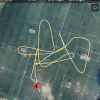
I can see the red triangle but it never really moves away from the home point - to show the flight path in real time even when in the main display.
When I view the flight logs it will show the red triangle moving appropriately and traces lines with each heading change.

Should I be able to see the same tracking during flight?
thanks for any guidance.

update:
I checked when offline the tracking shows only when using the satellite mode and satellite mode is not available offline. So perhaps if the phone had a data plan enabled the tracking would show with even small distances? (can't try it because phone is not active)
 

Attachments

  • satellite map flight track.png
    satellite map flight track.png
    463.1 KB · Views: 23
Last edited:
The Spark has to fly quite a distance before you will notice it has moved on the app. You can zoom in on the app and see it move sooner.
 
The Spark has to fly quite a distance before you will notice it has moved on the app. You can zoom in on the app and see it move sooner.

I did give that a thought, but it doesn't explain how at the same level of zoom on the map I can see traces less than 50 yds long using the logged flight. In actual flight I have gone 200 m and nada, so I give up on the map. What range would you say is quite a distance? thanks.
 
You can cache the maps.
Connect to a WIFI at home or make a hot spot with your phone, swipe to the map to where you will be, zoom in allowing the tiles to fill, zoom out and the tiles will be saved.
When you go out to your area of flight, the tiles will still be there.
 
  • Like
Reactions: Andre Levite
You can cache the maps.
Connect to a WIFI at home or make a hot spot with your phone, swipe to the map to where you will be, zoom in allowing the tiles to fill, zoom out and the tiles will be saved.
When you go out to your area of flight, the tiles will still be there.


Only street maps can be cached offline. I did look at the logged flight again, and it does show the trajectory traces with every turn when using just the street map.

I will follow up with DJI. Thanks for your input.
 
I did give that a thought, but it doesn't explain how at the same level of zoom on the map I can see traces less than 50 yds long using the logged flight. In actual flight I have gone 200 m and nada, so I give up on the map. What range would you say is quite a distance? thanks.


This you tube video shows green and white lines tracking the position of the drone relative to home on the map, apparently on an ios device. Could someone using an Android be kind enough to report if this is something that they can confirm works with Spark and Go App 4?

It would be ever so easy to get back home.
Again, I can see the flight path displayed when I replay the log file but with actual flying, I only see the street map (no cell service) and the home and drone positions but no lines even with the map zoomed in.

thank you.

Yes, the white (flight path) green (direction Home) AND brownish lines (for RTH) are there.
Just used them yesterday for a manual RTH from 2500ft out and an auto RTH from 3000 ft out
 
Yes, the white (flight path) green (direction Home) AND brownish lines (for RTH) are there.
Just used them yesterday for a manual RTH from 2500ft out and an auto RTH from 3000 ft out

Thank you pmshop, that is reassuring.

I just can't figure out why it doesn't work for me. I am running v 4.3.14 though I now see that the most recent is 3.16.

Could you tell me which version you run?
Do you have a cellular connection when you fly?
Does the tracking show when only using the simple map?

Do you concur that only the simple map can be cached offline?
thank you again.
 
Latest is 4.3.17 as of 3 days ago for iOS.
Just a thought, what OS are you using?
Android or iOS?
I always use the current release AFTER I read the initial reports on the release.
I am now using a Mavic Air and when I am around the house, it picks up the home network.
The controller connects to the mobile device via USB to mobile device connection.
Tracking shows on all the maps.

From what I have seen, both the simple and sat maps can be cached.
You just have to make sure you download every resolution.


hello pmshop,

So I think it comes down to the OS and Spark. I am using Android 8.0 Orio and the DJI manual (somewhere) does say that only the simple map is supported offline. 4.3.16 was the latest for Android - when I checked earlier today.

I will try flying close from home and see if tracking works while the phone has a WIFI connection.

I haven't contacted DJI - once in the past they were courteous but did not give me a suitable answer - other than your phone is not supported.

For anyone interested, the Cubot X19 works fine with Go App 4 and flies with FS which I think is the most demanding load test.

It runs on vanilla Android (even with multi-language keyboard support and FM recording), does support OTG (Cubot kept saying no) - has 4K and usb-c and the only minus I see - it's not the brightest thing, but good enough and the phone is too thick to strap onto the controller, but I put on an adapter to hold it in place over the control sticks.

Not really using cell service, but I did test it with an AT&T sim via tracfone and call sound was excellent. Not bad for the price.

thanks for your time.
 
  • Like
Reactions: pmshop
There in lies the difference between Android and iOS.
7 or 10 different mobile device models using iOS 12.2
Countless mobile devices using different variations of Android.
Which app version would you think is most stable and fully tested?

That is where most of the difference comes from.
One person could have no issues at all on their android device while someone else could have dozens of issues.

Any time, I love helping out.
 
So I think it comes down to the OS and Spark. I am using Android 8.0 Orio and the DJI manual (somewhere) does say that only the simple map is supported offline. 4.3.16 was the latest for Android - when I checked earlier today.

Correction,
App for iOS 4.3.17 was released less than 48 hours ago fixing a bug in 4.3.16 released 4 days ago from this post.
So I am not sure what revision that leave for Android.

Plus, I have no idea what the "bug fix" was.
 

Members online

No members online now.

Forum statistics

Threads
14,601
Messages
118,824
Members
18,013
Latest member
JulieMyers